Transformation and scenarios for the development of the settlement of Syria
Keywords:
geographic regions, planning regions, settlement, axes and strips of settlement, support centers, population geography, settlement structure, SyriaAbstract
The work is devoted to the comparison of geographical regions, planning regions and zones (territories) with different conditions of settlement of Syria. During the war years (since 2011), there have been dramatic changes in the structure of the national and regional settlement of Syria: the main axis and the zone of settlement instead of the Central became Coastal (Mediterranean). The options for further development of resettlement can be different: the restoration of the pre-war structure in the return migration of the population or the continuation of the concentration of the population in the cities of the coastal zone. The problem of restoring border areas of settlement is a problem. Territories affected by military operations require the development of special reconstruction projects. Very contrasting settlement conditions, an equal ratio of highly urbanized and rural areas, require the organization of a dense network of support centers for peripheral rural settlement. In Syria, service agencies work only in urban settlements (cities and towns). The geography of the rural population in Syria has not been developed yet, all attention is focused on the largest cities. The author tries to initiate research into the rural settlement of Syria and develop them in combination with the traditional geography of cities. In designing settlement has always used the fundamental status of the population geography. This, in view of the challenges of rebuilding Syria's resettlement, reinforces the relevance and practical significance of geographical research.
References
Айдрус И. Будущее карты транспортных артерий Сирии // Российский совет по международным делам. Т.18. 2014. [Электронный ресурс]. – Режим доступа: http://russiancouncil.ru.
Алексеев А.И., Ковалев С.А., Ткаченко А.А. География сферы обслуживания. Тверь, 1991. С.8–12.
Альсулейман М.И. Географическое моделирование сети опорных центров обслуживания в сельских районах Сирии// Актуальные проблемы географии: материалы международной научно-практической конференции. 17 ноября 2017 г. Астана,2017. С.186-190.
Альсулейман М.И. Особенности расселения Сирии// Вестн. Твер. гос. ун-та. Сер. «География и геоэкология». 2017. Вып. 2. С.33–42.
Альсулейман М.И. Особенности расселения Сирии: магистерская диссертация: 05.04.02 / М.И. Альсулейман. Тверь: ТвГУ, 2017. 97 с.
Альсулейман М.И. Процессы урбанизации в Сирии// География, экология, туризм: научный поиск студентов и аспирантов: материалы IV Всеросс. научно-практ. конф. – Тверь, Твер. гос. ун-т, 2016. С. 83–86.
Альсулейман М.И. Территориальная структура расселения Сирии // География, экология, туризм: научный поиск студентов и аспирантов: материалы IV Всеросс. научно-практ. конф. Тверь, Твер. гос. ун-т, 2017. С. 51–54.
История Сирии. М.: Институт стратегического анализа и прогноза (ИСАП). [Электронный ресурс]. – Режим доступа: http://www.easttime.ru/countries/topics/2/7/55.html.
Костюхин А.А., Киреев С.А. Сирия: гражданская война или реализация стратегии 4gw? (2012). [Электронный ресурс]. – Режим доступа: http://mir-politika.ru/1655-siriya-grazhdanskaya-voyna-ili-realizaciya-strategii-4gw.html.
Официальный сайт Центрального бюро статистики САР. [Электронный ресурс]. – Режим доступа: http://www.cbssyr.sy/.
Пирамиды населения стран мира. [Электронный ресурс]. – Режим доступа: https://www.populationpyramid.net/ru/%D1%81%D0%B8%D1%80%D0%B8%D1%8F/2010/; https://www.populationpyramid.net/ru/%D1%81%D0%B8%D1%80%D0%B8%D1%8F/2016/.
Подробная общегеографическая карта Сирии (2009). [Электронный ресурс]. – Режим доступа: http://www.ezilon.com/maps/asia/syria-physical-maps.html.
Политическая карта Сирии с городами и дорогами (2009). [Электронный ресурс]. – Режим доступа: http://www.ezilon.com/maps/asia/syria-maps.html.
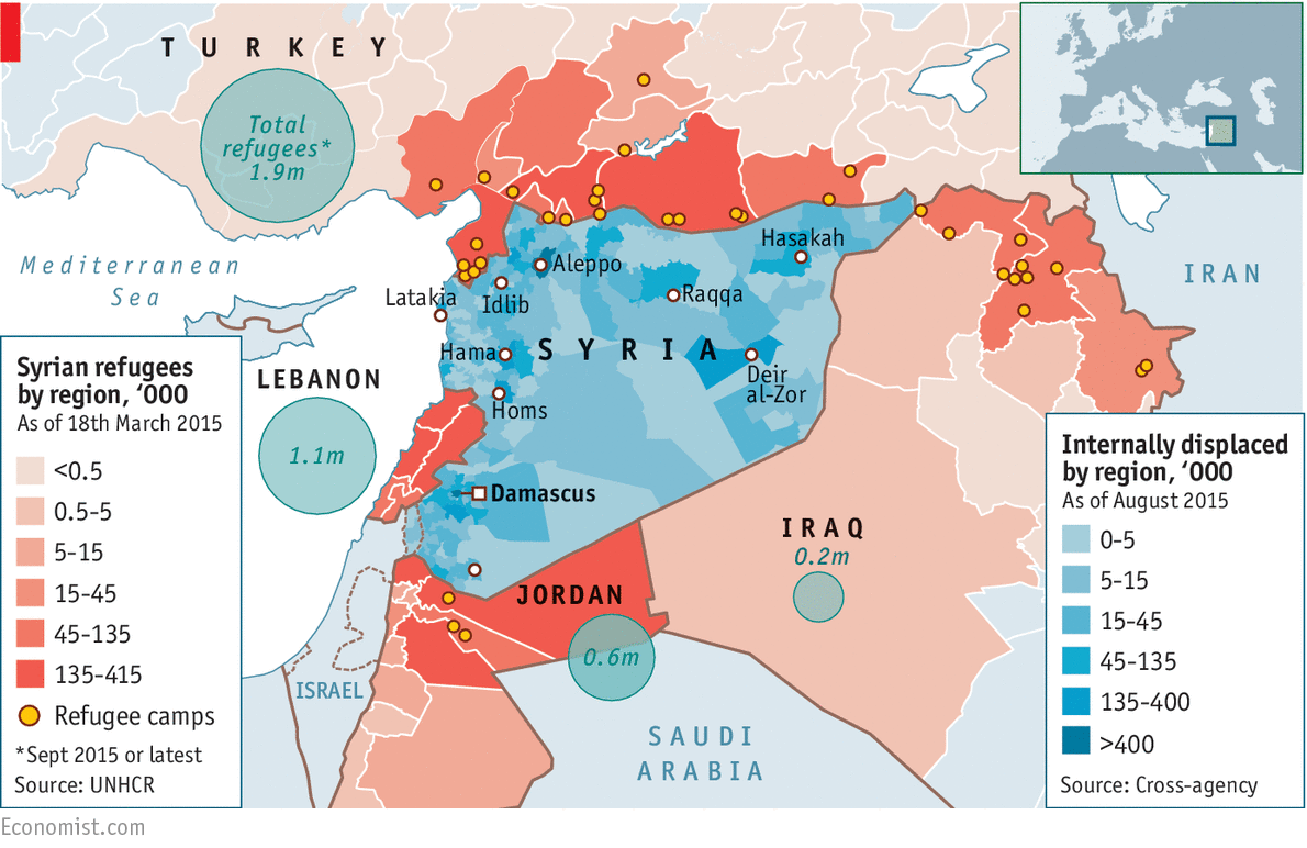
Сирийские беженцы в регионах соседних стран, тыс. чел. (по состоянию на 18 марта 2015), внутренне перемещенные по регионам по состоянию на август 2015 г., тыс. чел. [Электронный ресурс]. – Режим доступа:
Яковлева С.И. Интегральная модель регионального стратегического планирования// Псковский регионологический журнал, №26 (2). 2016. С.114-128.
Published
How to Cite
Conference Proceedings Volume
Section
License
Лицензиар (автор или коллектив авторов) обязуется предоставить Лицензиату (Тверской государственный университет) право использовать произведение следующим образом:
воспроизведение произведения;
распространение экземпляров произведения любым способом;
импорт оригинала или экземпляров произведения в целях распространения;
доведение произведения до всеобщего сведения путем передачи в эфир или по кабелю или с помощью иных аналогичных средств.
передавать за вознаграждение право использования произведения третьим лицам.
Территория, на которой допускается использование произведения, не ограничена.
Права использования произведения предоставляются Лицензиату с сохранением за Лицензиаром права выдачи лицензий другим лицам.